Lebanon is a country in the Middle East. Officially the Lebanese Republic, the country is located in the Levant region of West Asia. The human population in Lebanon dates even earlier than 5000 BC, with evidence of Neolithic and Chalcolithic fishing communities, such as those at Byblos, living along the Mediterranean coast over 8,000 years ago. Byblos is considered one of the oldest continuously inhabited cities in the world, with settlements dating before 5000 BC.
Around 64 BC, the region was a part of the Roman Empire and then the Byzantine Empire. In the early 16th century, Lebanon came under Ottoman rule, and under Ottoman sultan Abdulmejid I, the first Lebanese proto-state, the Mount Lebanon Mutasarrifate, was established as a home for Maronite Christians, as part of the Tanzimat reforms. We will learn of the timeline further in the article.
As of 2026, Lebanon's population is estimated to be approximately 5.9 million, with a projected increase of 21 per cent to 6.9 million by 2050. Lebanon is a developing, middle-income country, ranked 112th on the Human Development Index. Read below to learn where Lebanon is located on the world map, its bordering countries, capital, and geography trivia.
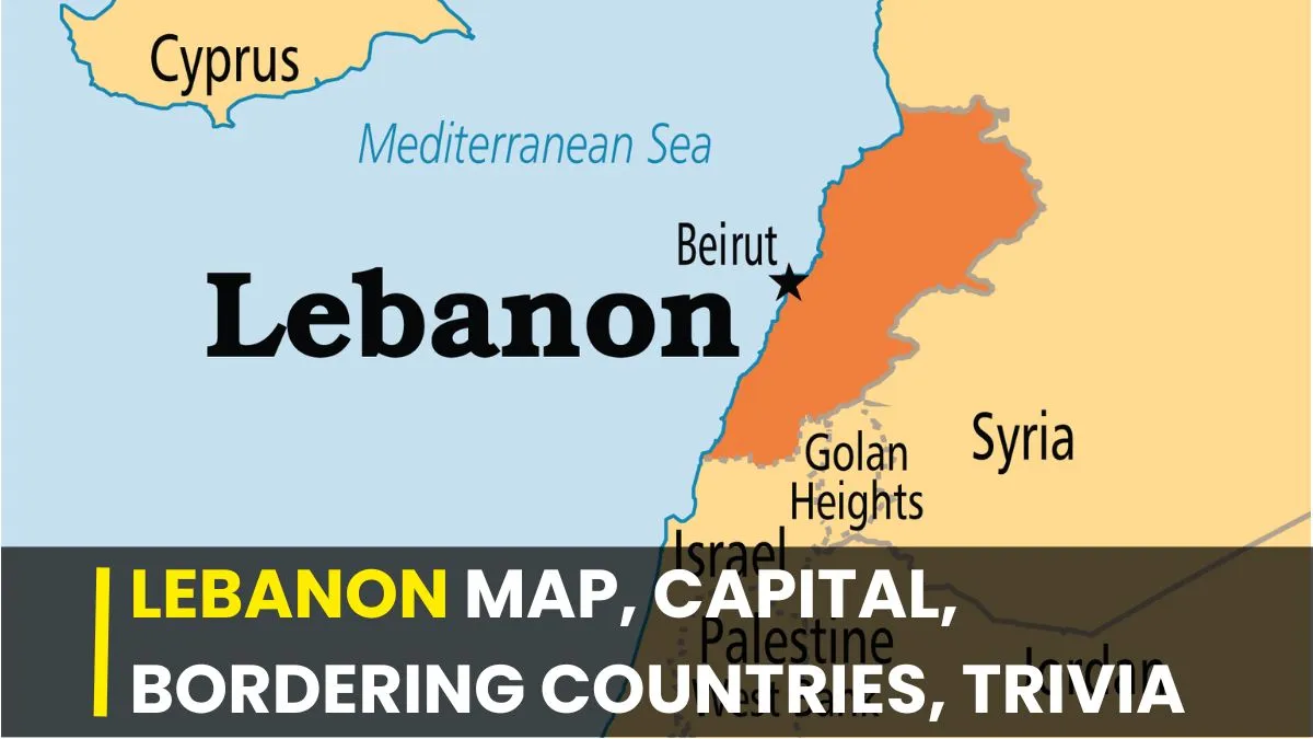
Where is Lebanon located on the world map?

Lebanon is a Middle Eastern country in Western Asia. With a total area of 10,452 square kilometers, Lebanon is often described as the country situated at the crossroads of the Mediterranean Basin and the Arabian Peninsula.
Lebanon Bordering Countries
Located in the Levant region, Lebanon's bordering contries are:
-
To the North and East: Syria. This is Lebanon’s longest land border, wrapping around the country’s northern and eastern flanks.
-
To the South: Israel. This border is defined by the "Blue Line," a demarcation line published by the United Nations.
-
To the West: The Mediterranean Sea, providing over 200 kilometers of coastline.
Lebanon Capital
Beirut is the capital of Lebanon. Often referred to as the "Paris of the Middle East," Beirut is the country’s largest city. Beirut served as a vital administrative capital under the Ottoman Empire.
After the collapse of the Ottoman Empire in 1918, Lebanon was placed under a French Mandate by the League of Nations (1920–1943), becoming the state of "Greater Lebanon" in 1920.
On September 1, 1920, General Henri Gouraud proclaimed the State of Greater Lebanon with Beirut as its capital, expanding the former Mount Lebanon autonomous district to include coastal cities and the Bekaa Valley.
Lebanon was declared a republic on May 23, 1926, adopting a constitution, with Beirut as its capital.
What was Lebanon called before 1943?
Why 1943? Lebanon gained independence from Free France in 1943.
- Ottoman Era (until 1918): Known as the Mount Lebanon Mutasarrifate after 1861, part of the Ottoman Empire.
- Greater Lebanon (1920–1926): Proclaimed by France on September 1, 1920, establishing modern boundaries.
- Lebanese Republic (1926–1943): The official name under the French Mandate, before full independence.
Geography Trivia
Lebanon is a narrow strip of land along the Mediterranean Sea with a 225 km (140 mi) coastline. The country is small, just over 10,000 sq.km.
Lebanon has no desert land. Lebanon is the only Arab country with zero desert land, setting it apart in the Middle East.
The geography of Lebanon features snowy mountains, dense forests, and a lush coast, rather than sand dunes.
The name "Lebanon" is indeed derived from the Semitic root LBN, meaning "white," which directly refers to the snow-capped peaks of the Mount Lebanon range.
About 73 per cent of the country is highly mountainous. Two main ranges run parallel: the Lebanon Mountains in the west and the Anti-Lebanon Mountains in the east.
Lebanon has prominent snow-covered mountains, with peaks in the Mount Lebanon and Anti-Lebanon ranges.
Qurnat as Sawda' is the highest peak in Lebanon at 3,088 meters (10,131 ft). It is the peak of the Jabal al Makmel range in the Mount Lebanon range.
The country has roughly 15 rivers, of which the 140 km-Litani River is the longest and flows through the Bekaa Valley.
The climate of Lebanon is Mediterranean, with rainy winters and hot, dry summers.
The green Lebanon cedar on the flag of Lebanon, adopted in 1943, is the country's national symbol. The Lebanon cedar is found on the Mount Lebanon range.
Also read: Which countries border the Red Sea?


-1777116813191_t.webp)

