Check the Complete List of Districts and Administrative Divisions in Bihar
Discover how many districts and administrative divisions are in Bihar. Check the complete list of 38 districts, 9 divisions, area, and population data.

Key Takeaways
-
There are 38 districts in Bihar.
-
In the state of Bihar, there is a total of 9 administrative divisions.
-
West Champaran is the largest district in Bihar, approximately 5228 square km
-
Sheohar is the smallest district in Bihar, approximately 443 square km
-
Bihar is divided into two distinct regions of the Ganga: North of the Ganga River, and South of the Ganga River
Bihar is located in the eastern part of India. It is a landlocked state in the Sub-Tropical region of the temperate zone. Bihar is a growing state , which is known for its rich culture, heritage and rapidly growing infrastructure state.
Understanding its administrative structure is important and crucial for its governance and regional diversity.
In this article, explore all the districts in Bihar, all the data for Bihar’s districts has been taken from Bihar Vikas Mission, Government of Bihar.
List of all Districts of Bihar
There are 38 districts in Bihar, and these 38 district are divided into 9 Administrative Divisions. These districts are presided by either IAS officer, as District Magistrate, or by the Deputy Commissioner.
Check the complete list of 38 districts in Bihar with the table given below:
| S.No | District | District Headquarter | Area (sq km) | Population (Census 2011) |
| 1. | Araria | Araria | 2,829 | 2,811,569 |
| 2. | Arwal | Arwal | 637 | 699,000 |
| 3. | Aurangabad | Aurangabad | 3,303 | 2,540,073 |
| 4. | Banka | Banka | 3,018 | 2,034,763 |
| 5. | Begusarai | Begusarai | 1,917 | 2,970,541 |
| 6. | Bhagalpur | Bhagalpur | 2,569 | 3,037,766 |
| 7. | Bhojpur | Arrah | 2,473 | 2,728,407 |
| 8. | Buxar | Buxar | 1,624 | 1,706,352 |
| 9. | Darbhanga | Darbhanga | 2,278 | 3,937,385 |
| 10. | East Champaran | Motihari | 3,969 | 5,099,371 |
| 11. | Gaya | Gaya | 4,978 | 4,391,418 |
| 12. | Gopalganj | Gopalganj | 2,033 | 2,562,012 |
| 13. | Jamui | Jamui | 3,099 | 1,760,405 |
| 14. | Jehanabad | Jehanabad | 1,569 | 1,125,313 |
| 15. | Khagaria | Khagaria | 1,486 | 1,666,886 |
| 16. | Kishanganj | Kishanganj | 1,884 | 1,690,400 |
| 17. | Kaimur | Bhabua | 3,363 | 1,626,384 |
| 18. | Katihar | Katihar | 3,056 | 3,071,029 |
| 19. | Lakhisarai | Lakhisarai | 1,229 | 1,000,912 |
| 20. | Madhubani | Madhubani | 3,501 | 4,487,379 |
| 21. | Munger | Munger | 1,419 | 1,367,765 |
| 22. | Madhepura | Madhepura | 1,787 | 2,001,762 |
| 23. | Muzaffarpur | Muzaffarpur | 3,173 | 4,801,062 |
| 24. | Nalanda | Bihar Sharif | 2,354 | 2,877,653 |
| 25. | Nawada | Nawada | 2,492 | 2,219,146 |
| 26. | Patna | Patna | 3,202 | 5,838,465 |
| 27. | Purnia | Purnia | 3,228 | 3,264,619 |
| 28. | Rohtas | Sasaram | 3,850 | 2,959,918 |
| 29. | Saharsa | Saharsa | 1,702 | 1,900,661 |
| 30. | Samastipur | Samastipur | 2,905 | 4,261,566 |
| 31. | Sheohar | Sheohar | 443 | 656,916 |
| 32. | Sheikhpura | Sheikhpura | 689 | 634,927 |
| 33. | Saran | Chhapra | 2,641 | 3,951,862 |
| 34. | Sitamarhi | Dumra, Sitamarhi | 2,199 | 3,423,574 |
| 35. | Supaul | Supaul | 2,410 | 2,229,076 |
| 36. | Siwan | Siwan | 2,219 | 3,330,464 |
| 37. | Vaishali | Hajipur | 2,036 | 3,495,021 |
| 38. | West Champaran | Bettiah | 5,229 | 3,935,042 |
Bihar Map
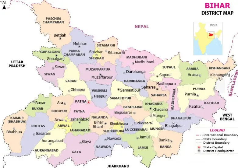
Source: dcmsme.gov
How many Administrative Divisions are there in Bihar?
According to the Development Commissioner, Micro, Small & Medium Enterprises, Government of India, Bihar is distributed in 9 administrative divisions.
Check the complete list of 9 administrative divisions in Bihar with the table given below:
| Division | Bihar Districts |
| Patna | Bhojpur, Buxar, Kaimur, Patna, Rohtas, Nalanda |
| Saran | Saran, Siwan, Gopalganj |
| Tirhut | East Champaran, Muzaffarpur, Sheohar, Sitamarhi, Vaishali, West Champaran |
| Purnia | Araria, Katihar, Kishanjganj, Purnia |
| Bhagalpur | Banka, Bhagalpur |
| Darbhanga | Darbhanga, Madhubani, Samastipur |
| Kosi | Madhepura, Saharsa, Supaul |
| Magadh | Arwal, Aurangabad, Gaya, Jehanabad, Nawada |
| Munger | Begusarai, Jamui, Khagaria, Munger, Lakhisarai, Sheikhpura |
Interesting Facts About Bihar
-
Bihar is the third most populated state in India, approximately 10,40,99,452 people according to the 2011 census given by the Director of Economics and Statistics
-
The principal commercial product of Bihar is rice,wheat, lentils, maize(corn), sugarcaneand for fruits, they are mangoes, bananas, jack‐fruit, andlitchis.
-
The idea of non-violence was first introduced in Bihar.
-
In the Delhi Durbar of 1911, King George V made the historic announcement separation of Bihar from Bengal. The formal separation of Bihar from Greater Bengal was effected in April 1912 by the Government of India Act, 1912, and the formal proclamation was made on March 22, 1912.
-
The Tenth Sikh Guru, Guru Gobind Singh Ji, was born on December 22, 1666, in Patna Sahib, Bihar, India.
-
Bihar was known for its hub of trade and culture during the Vedic era.
-
From ancient times, Bihar was the centre of knowledge, culture, and power.
-
Bihar has the second-highest proportion of IAS officers.
Key Takeaways

Prabhat Mishra is a Subject Matter Expert and digital journalist with an extensive background in the competitive exam landscape and over 4 years of experience in education, national and international news, and current affairs. Over his tenure with top knowledge platforms like Mentorship India, IAS BABA, IAS SARTHI, and now Jagran Josh, he has a deep understanding of government exams like UPSC and State PCS, including UP and Bihar, as he has already qualified for the UPPCS 2022 Mains and Bihar 68th Mains. With his core expertise in history, polity, geography & current affairs, he specialises in creating well-researched, aspirant-centric content and simplifying complex topics for competitive examinations.


