Bhabar, Terai, Bhangar and Khadar: The 4 Belts of the Indo-Gangetic Plains
The Indo-Gangetic Plains a vast and fertile region, are divided into four distinct horizontal belts: Bhabar, Terai, Bhangar and Khadar. These regions are differentiated by their relief features, soil characteristics and hydrological properties.
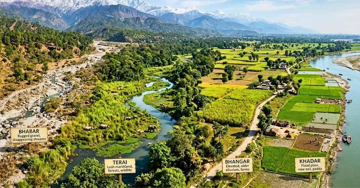
The North Indian Plains of India also called the Indo-Gangetic Plains, are widely regarded as one of the largest and most fertile areas in the world with high population density. They far from the dry regions of the Indus Basin in the west to the fertile delta of the Ganges and Brahmaputra in the east and they encompass a vast area of approximately 7.5 to 7.8 lakh square kilometers.
The plains are formed with the process of continuous deposition of silt, clay and sand by the three river systems: Indus, Ganges and Brahmaputra and they are called the breadbasket of India. The entire landform does not have the same physical features.
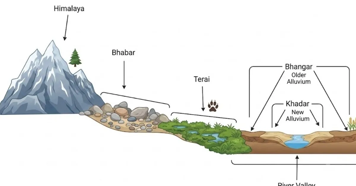
There are four different horizontal strips or belts of the North Indian Plains which are called as Bhabar, Terai, Bhangar and Khadar, based on their relief features, soil age and texture and hydrology.
The Bhabar Region (The Foothill Zone)
-
Location and Extent of Bhabar region: The Bhabar region can be found just south of the Shiwalik mountains and is a long strip of land extending from the Indus in the west to the Tista rivers in the east. Its width varies between 8 to 16 km as it widens in the western Himalayas (Punjab/Jammu) and narrows in the east.
-
Formation and Characteristics: Rivers flowing down from mountains meet low gradients and lose their force which leads to the deposition of huge boulders, gravel, stones and other sediments in the form of overlapping alluvial fans.
-
Hydrology and Agriculture: The region of Bhabar is unique for being highly porous. Since the sediments consist of large and loose pieces of rocks they disappear underground.
-
Economic Importance: Due to the rocky and porous nature of the soil in the region, it is highly unsuitable for agricultural activities. Only large trees with deep root systems can survive here.
The Terai Belt (The Marshy Lowlands)
-
Location and Extent: Located just south of the Bhabar region the Terai belt is a wet marshy stretch running parallel to it. It is 15 to 30 km in width and is prominent in the eastern parts due to heavy rainfall.
-
Formation and Characteristics: The underground rivers that disappear in the Bhabar plain come to the surface, and this results in swampy, wet and poorly drained conditions.
-
Biodiversity and Agriculture: Traditionally, this region has been known for its thick wet forests and abundant plant and animal diversity.
-
But today, large parts particularly in Uttarakhand, Uttar Pradesh, Haryana and Punjab have been turned to agriculture.
-
Soil in this region is rich in nitrogen and organic matter thus suitable for cultivation of crops like sugarcane, rice, wheat and maize.
The Bhangar Belt (Old Alluvial Formation)
-
Location and Alluvial Extent: The term ‘Bhangar’ denotes that it is one of the older alluvial plains to be formed millions of years ago. Bhangar occupies the maximum part of the Indo-Gangetic plain.
-
Formation and Characteristics: Bhangar is the product of former geological ages and is situated above the flood level of rivers. The soil of Bhangar is generally of a dark color and is inferior in fertility to Khadar.
-
Regional Variations: Bhur: Also referred to as high sandy ridges formed as a result of wind action, these landforms are located near the banks of the Ganga in the Upper Ganga-Yamuna Doab.
-
Barind Plains: Referring to the old alluvium of the region, these elevated formations of high alluvial deposit can be seen in some areas of the Bengal delta region.
-
Economic Value: Though it is not as fertile as Khadar due to its old geology, Bhangar is well-drained land and can be used for agricultural activities.
The Khadar Region (The New Alluvial Floodplains)
-
Location and Area: Khadar refers to the low-lying floodplains alongside the flowing channels of rivers.
-
Formation and Features: Khadar is made up of new alluvium (silt, mud, clay, and sand) and is deposited by rivers in the form of fertile and nutrient-rich crops almost every year in monsoon floods.
-
Agricultural Significance: Due to its annual deposition of sediment, Khadar is very fruitful and does not need many fertilizers.
-
Khadar is the main agricultural area where wheat, rice, sugarcane, maize, and oilseeds are grown in very large quantities in Punjab and Haryana.
Bhabar vs Terai vs Bhangar vs Khadar
| Feature | Bhabar | Terai | Bhangar | Khadar |
| Position | Directly south of Shiwaliks | South of Bhabar | Away from rivers, higher terraces | Close to river banks, lowlands |
| Soil Texture | Coarse pebbles, gravel, rocks | Finer alluvium, marshy, damp | Older alluvium with 'Kankar' | Newer alluvium (silt, clay, sand) |
| Hydrology | Highly porous; streams disappear | Streams re-emerge; waterlogged | Well-drained, above flood levels | Prone to annual flooding |
| Agricultural Use | Unsuitable (only large trees) | Good for rice, wheat, sugarcane | Moderately fertile; cultivated | Extremely fertile; |
The geological differentiation of the Indo-Gangetic Plains into the Bhabar, Terai, Bhangar and Khadar segments showcases how landscape, running water and sedimentation determines man’s geography and agrarian prosperity.
From the hard, aquifer-like gravels of the Bhabar to the swampy richness of the Terai and from the old terraces of the Bhangar to the yearly renewed soils of the Khadar, each region plays its own environmental and economic role.

Manisha Waldia is a distinguished content strategist with 5 years of experience crafting premium educational content for UPSC and State PCS, with a focus on deep conceptual analysis across Polity, Geography, History, and Environment. She currently brings this expertise to Jagran Josh, where she covers major national and international events, current affairs, and static general knowledge. Over her career, Manisha's specialized insights have led her to curate high-impact materials and serve as a UPSC Mains answer-evaluator for India’s top institutes—including Drishti IAS, Shubhra Ranjan IAS, Study IQ, GS Score, and PWonlyIAS. She has also worked alongside leading NGOs like Oxfam India and Avani Kumaon.
Contact: manisha.waldia@jagrannewmedia.com



![[Out] UGC NET June 2026 Result Live: यूजीसी नेट रिजल्ट ugcnet.nta.nic.in जारी, डायरेक्ट लिंक से करें चेक](https://img.jagranjosh.com/images/2026/August/2782026/UGC-NET-Result-2026-Marksheet-link-pdf.jpg)