Key Points
- The Coromandel Coast spans Tamil Nadu and Andhra Pradesh.
- It receives most rainfall from the Northeast Monsoon (Oct-Dec).
- Name derives from 'Cholamandalam,' land of the Chola dynasty.
A coastline is where land meets the ocean. These borders are always changing as waves and tides shape them. Canada has the world's longest coastline at over 202,000 kilometres.
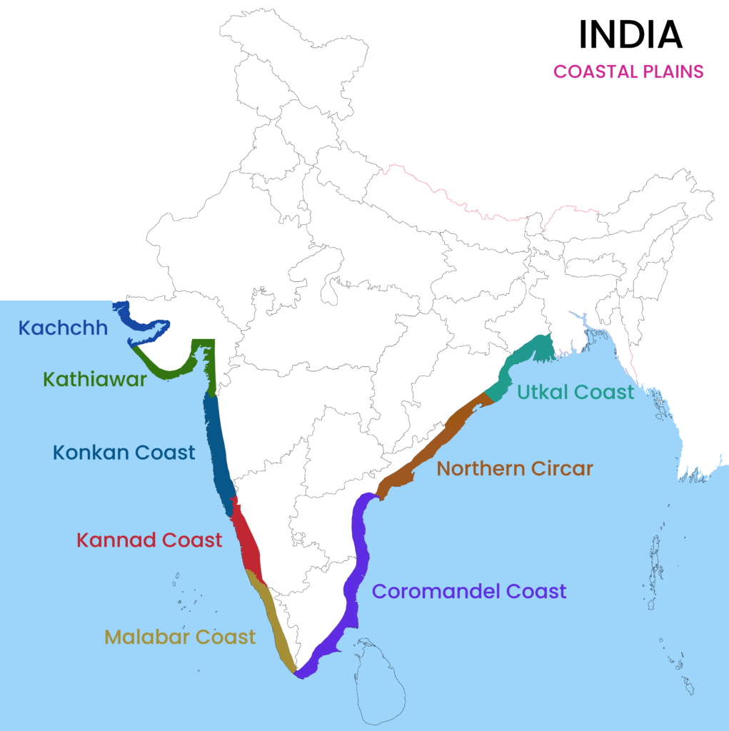
India's coastline is about 7,517 kilometres long, and Gujarat has the longest section. The Indian coast is split into the Western and Eastern coasts, each with its own name and history.
Do you know which part of India's coast is known for its rich history and beautiful beaches? In this article, we'll explore the coast that shapes the southeastern edge of the country.
ALSO READ| Which Country Has the Longest Coastline in the World?
Which Coast Is Known As The Coromandel Coast?

Source: The Economist
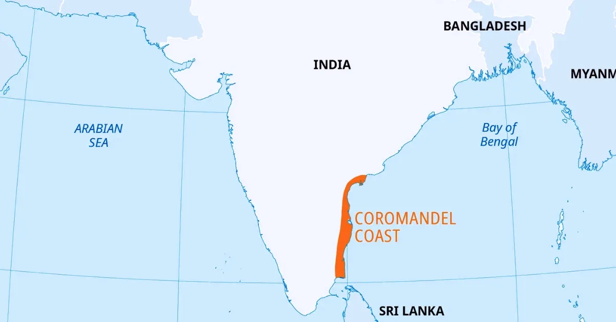
The Coromandel Coast is the broad coastal plain located along the southeastern edge of India. It stretches from the False Divi Point in the north to Kanyakumari in the south, covering an area of about 22,800 square kilometres. This coastline mainly spans the states of Tamil Nadu and Andhra Pradesh.
The name is believed to be derived from the Tamil phrase Cholamandalam, meaning the "land of the Cholas", an ancient dynasty that ruled the region. Geographically, it is unique because it remains mostly flat, with an average elevation of just 100 meters above sea level.
Unlike the western coast, this region receives most of its rainfall from the Northeast Monsoon between October and December, making its agricultural cycle different from the rest of India.
7 Lesser-known facts about the Coromandel Coast
- The coast sits on a passive continental margin, which is why it lacks the high mountain cliffs seen on the Western Ghats.
- It is one of the few places in India where 60% of annual rainfall occurs during winter due to "retreating monsoons."
- The coast is a "prograding" shoreline, meaning it is slowly expanding outward into the sea due to heavy silt from rivers like the Kaveri and Krishna.
- Because of its shallow, gently sloping continental shelf, the 2004 Indian Ocean tsunami waves increased in height significantly before hitting the shore.
- The region houses the Neyveli Lignite fields, containing one of the largest deposits of brown coal in Southeast Asia, formed from ancient tropical vegetation.
- It hosts India's second-largest brackish water lagoon, which acts as a natural carbon sink and a vital barrier against storm surges.
- Due to high evaporation rates and specific soil chemistry, certain areas along the coast are naturally primed for large-scale salt production, contributing to a major portion of India's salt supply.
Why is it called Coromandel?
Source: LotusArise
Most people believe the name comes from the Tamil word Cholamandalam, which means the "Realm of the Cholas."
This refers to the powerful Chola Dynasty that ruled Southern India for many years. When Portuguese and Dutch explorers reached the area in the 16th century, they found the local name hard to say and shortened it to "Coromandel".
Some historians think it might also come from Kuru-Mandala, meaning the land of the Kurus, but the Chola origin is the most widely accepted by experts.
MUST READ| Which State has the Longest Coastline in India?
What Is Coromandel Famous For?
The Coromandel Coast is famous for its textile heritage, especially Madras Check and hand-painted Kalamkari fabrics that were once highly valued in global trade.
Its geography is unique because, unlike most of India, it gets the most rain in winter from the Northeast Monsoon.
The region is also known for Dravidian architecture, with UNESCO World Heritage shore temples in Mahabalipuram and Marina Beach in Chennai, which is the world's second-longest urban beach.
Which State Is Located On The Coromandel Coast?
The Coromandel Coast covers much of Tamil Nadu and Andhra Pradesh. It starts at False Divi Point in Andhra Pradesh and runs south to Kanyakumari, the tip of Tamil Nadu.
The coast also includes Puducherry. This region is important for the local economy, with major seaports like Chennai and Ennore, as well as many fishing communities and farmland.
What Is The South Eastern Coast Of India Called?
/english-betterindia/media/post_attachments/uploads/2018/01/Untitled-design-67-1.jpg)
Source: The Better India
The south-eastern coast of India is known as the Coromandel Coast. This area makes up the eastern part of the Eastern Coastal Plains and lies between the Eastern Ghats and the Bay of Bengal.
The northern section of the eastern coast is called the Northern Circars, but the land from the Krishna River delta to the tip of the peninsula is called the Coromandel. This region is known for its wide, sandy beaches and fertile river deltas.
WHAT'S NEXT| Which Indian Region Has a Coastline on Both the Arabian Sea and the Bay of Bengal?


Comments
All Comments (0)
Join the conversation