Kentucky, a name that conjures images of rolling bluegrass hills, thoroughbred horses, and the distinct taste of bourbon, is a state steeped in a rich and complex history. Nestled in the eastern and southern central region of the United States, Kentucky is defined by its waterways, with rivers forming most of its boundaries. From its earliest days as a hunting ground for Native American peoples to its pivotal role as a border state during the American Civil War, Kentucky has always been a place of crossroads and contrasting identities.
Its diverse landscape, ranging from the rugged Appalachian Mountains in the east to the fertile lowlands of the Mississippi River in the west, has shaped its economy, culture, and settlement patterns. Beyond the iconic symbols often associated with the state, Kentucky boasts a vibrant cultural scene, a robust economy, and a commitment to education
Check out: Which Country is the Largest Producer of Saffron?
What is the meaning of the Kentucky flag?
Kentucky's flag prominently features the state seal on a field of deep blue. The seal itself depicts two men, one a frontiersman and the other a statesman, embracing, symbolizing the unity of the past and present within the state. Encircling them is the state motto, "United We Stand, Divided We Fall," a poignant reflection of Kentucky's history, particularly its struggle during the Civil War. Below the figures, the words "Commonwealth of Kentucky" are inscribed, and the date "1792" marks the year of its admission to the Union.

Source: worldatlas.com
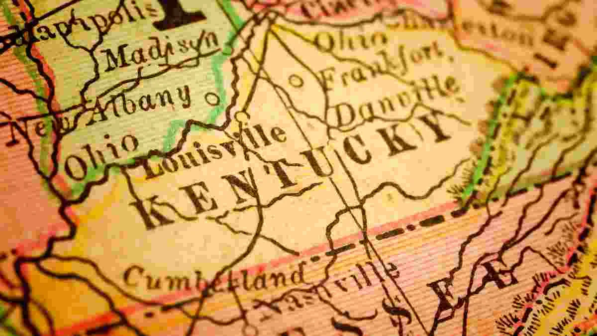
Which part of the USA is Kentucky?
Kentucky is a constituent state of the United States of America, situated in the east-south-central region. Its boundaries are primarily defined by rivers: the Tug and Big Sandy rivers separate it from West Virginia to the east and northeast, while the Ohio River forms its northern border with Ohio, Indiana, and Illinois. To the west, the Mississippi River marks a short southwestern border with Missouri. The state shares a nearly straight southern border with Tennessee for about 425 miles (685 km) and an irregular, mountainous southeastern border with Virginia.
Within its 40,408 square miles (104,656 square km) of area, Kentucky encompasses three major physiographic regions of the United States: the Appalachian Highlands (the Appalachian Plateau), the Interior Lowlands, and the Coastal Plain.

Source: worldatlas.com
What is the capital of Kentucky?
Frankfort is the state capital of Kentucky, located on the Kentucky River between the state's two largest cities, Louisville and Lexington. It was chosen as the capital in 1792 largely because of its central location. The city is a hub for state government, featuring the beautiful Beaux-Arts style Kentucky State Capitol building, and is also an important part of the state's famous Bluegrass region. Though it's one of the smaller state capitals in the U.S. by population, it has a rich history and is known for its role in Kentucky's bourbon industry.
What is the geography like in Kentucky?
Kentucky's geography is quite varied, stretching across several distinct regions. The eastern part of the state is dominated by the heavily forested Cumberland Plateau and the Appalachian Mountains, which include the state's highest point. Moving west, you find the famous Bluegrass region, known for its gently rolling hills, fertile soil, and horse farms. The south-central and western areas feature the Pennyroyal Plateau, famous for its limestone geology, which created the massive Mammoth Cave system. Finally, the far west, known as the Jackson Purchase, is a flat, low-lying area bordered by the Ohio and Mississippi Rivers.
What is the History of Kentucky?
Kentucky's history began as a hunting ground for Native American peoples like the Cherokee, Shawnee, and Chickasaw. European exploration started in the 17th century, but Daniel Boone's arrival in 1769 spearheaded significant European settlement, with places like Boonesborough established by 1775. After the American Revolution, settlers flooded the region, and Kentucky joined the Union on June 1, 1792, as the 15th state and the first west of the Appalachians.

Source: wikimedia.org
By 1800, its population, including enslaved people, had grown rapidly. Slavery became a central issue, aligning Kentucky's interests with the South, despite the state's 1833 ban on importing slaves for resale. During the Civil War (1861–65), Kentucky was divided, with residents fighting for both the Union and the Confederacy. Post-war, the state experienced profound social and economic changes, including the emancipation of slaves and a shift in its economic focus. The late 19th and early 20th centuries saw economic diversification, but also labor conflicts in coal regions and infamous family feuds. The Great Depression brought challenges, but also federal programs that helped build infrastructure.
Does Kentucky have a good education system?
Kentucky's education system is considered average compared to other states, typically ranking in the middle of national lists. The state has made big improvements from lower historical rankings, showing good progress in its public schools' academic performance, often matching the national average. However, the state still faces challenges with overall adult college attainment rates, which keep its overall "most educated state" ranking lower.
Check out: All About North Dakota: Flag, Map, Geography, History, Facts, and Education
Conclusion
So, Kentucky, with its interesting blend of Southern charm and Midwestern practicality, truly embodies the concept of a "crossroads" state. From its distinctive physiographic regions with each its own unique character and resources, to the complex history shaped by indigenous peoples, and the profound divisions of the Civil War, Kentucky offers a fascinating study in American identity.


-1759226738660.png)


Comments
All Comments (0)
Join the conversation